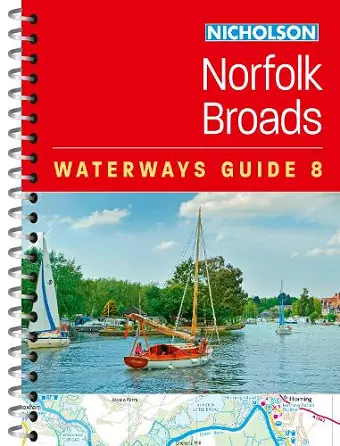
Norfolk Broads (8)
For Everyone with an Interest in Britain’s Canals and Rivers
Nicholson Waterways Guides author
Format:Spiral bound
Publisher:HarperCollins Publishers
Published:11th Sep '25
Should be back in stock very soon
Explore Britain's canals and rivers with the Nicholson bestselling guides.
For all users of the inland waterways. This popular and practical guide covers the waterways of the Broads National Park, including the Norfolk and Suffolk Broads and the Rivers Ant, Bure, Thurne, Wensum, Yare, Chet and Waveney.
The up-to-date detailed maps clearly show the location of essential features such as boating facilities, as well as pubs, shops and restaurants in the area. There are comprehensive navigational notes and descriptive text on the history of The Broads, and on local services and places of interest, for which postcodes are included – ideal for use with sat-navs. Scale: 2 inches = 1 mile, 3 cm = 1 km.
This practical A5 guide features 'lie flat' spiral binding and 'book mark' back cover flap for ease of reference.
The Broads are one of Britain's best-known holiday boating areas. They make up Britain's largest and most important protected wetland and are a national park providing a home to some of the rarest plants and animals in the country. A unique and enchanting wetland, with over 125 miles of lock-free navigable tidal waters, all waiting to be explored.
"few serious boaters will venture out without a Nicholson's Guide. There is a wealth of information…and the guides are valuable for cyclists and walkers too." The Inland Waterways Association.
ISBN: 9780008772222
Dimensions: 210mm x 148mm x 6mm
Weight: 160g
96 pages