Hadrian's Wall Path Trail Map (4009)
Trails Illustrated
Format:Sheet map, folded
Publisher:National Geographic Maps
Published:15th Aug '24
Should be back in stock very soon
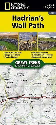
The Hadrian's Wall Path Topographic Map Guide booklet makes a perfect traveling companion when traversing the route. A detailed description of each trail section is included that tells travelers about the many landmarks encountered along the way. As a demonstration of the Roman Empire's power and strength, Emperor Hadrian conceived the idea to build a wall to deter attacks on his Roman territory Britannia. At the time - and even today - building a 73-mile (118-kilometer) long wall, standing 5 meters (16 feet) high and 3 meters (10 feet) wide was an exceptional undertaking. In a.d. 122, approximately 15,000 soldiers were enlisted to begin construction of this project, which included forts, turrets, bridges, milecastles, and the interconnecting wall. Today, Hadrian's Wall is recognized as a UNESCO World Heritage Site. From Bowness-on-Solway to Wallsend, the 84-mile (135-kilometer) Hadrian?s Wall Path meanders the wild and scenic English countryside providing an opportunity to learn more about these historic sites.
ISBN: 9781566959421
Dimensions: unknown
Weight: 90g
46 pages