County Kerry Xploreit map
1:100 000
Format:Sheet map, folded
Publisher:Fountain Software and Publications Ltd
Published:18th Jun '24
Should be back in stock very soon
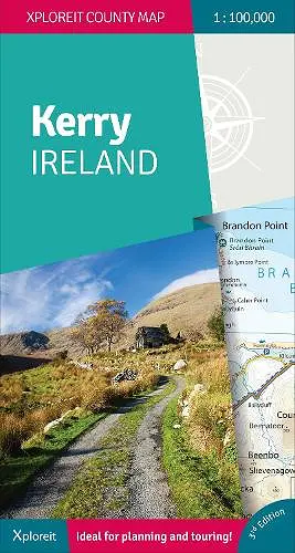
Whether you need to plan your daily activities or just need a quick scan of your existing location, this map is an excellent companion for your adventures in County Kerry. For many years now this convenient and informative Xploreit touring map has guided thousands of visitors and locals alike to the best drives, cycle routes, walks and other points of interest in Kerry (affectionately known as the 'The Kingdom'). It has been fully revised and updated for its 3rd Edition. The Kerry section of the new long-distance Euro Velo Atlantic Cycle Route is included along with the new greenways including Listowel to Abbeyfeale and Tralee to Fenit. Topography is shown by altitude colouring with contours at 30m and numerous geographical features are identified. The road network includes local roads and tracks with scenic roads highlighted including the Kerry section of the Wild Atlantic Way and associated Discovery Points. Each centimetre on the map is equivalent to 1 Kilometre so the map provides a good level of detail but is clear and easy to follow. The map sheet is double-sided for easy reading and folding and there is a good overlap between north and south. All of County Kerry on one touring map Easy to read, clear mapping Local drives, cycle routes and walks Large range of tourist attractions highlighted Place name index GPS compatible grid in decimal degrees
ISBN: 9781738413638
Dimensions: unknown
Weight: 100g
1 pages
3rd New edition