Hadrian's Wall Path Map Booklet
1:25,000 OS Route Mapping
Format:Paperback
Publisher:Cicerone Press
Published:4th Aug '23
Should be back in stock very soon
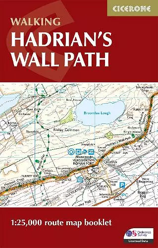
Uncover the fascinating history and stunning landscapes of the iconic Hadrian’s Wall Path National Trail. Stretching 84 miles (135 km) from Bowness-on-Solway on the Cumbrian coast to Wallsend in Newcastle, this legendary route traces the line of the UNESCO World Heritage Roman frontier.
This map book provides all the route mapping you need to walk the entire Hadrian’s Wall Path National Trail:
- Features 1:25,000 Ordnance Survey (OS) mapping for accuracy and clarity
- Explore historic Roman sites, including Birdoswald, Housesteads, Chesters Fort, Segedunum, Vindolanda, and Carlisle Castle
- Compact and portable size, perfect for your jacket pocket or rucksack
- Suitable for walking in either direction, from west to east or east to west
- 2-stage route extension through Newcastle to South Shields on the east coast is also shown
- For step-by-step route descriptions, an accompanying Cicerone guidebook, ‘Hadrian’s Wall Path,’ is also available
Whether you’re captivated by ancient Roman history, drawn to breathtaking scenery, or seeking a memorable long-distance adventure, this map will help you plan and enjoy every step of your journey along Hadrian’s Wall Path.
ISBN: 9781786311511
Dimensions: 166mm x 106mm x 5mm
Weight: 60g
56 pages
2nd Revised edition