M17 North Tuscan Islands to Rome
Italy West Coast
Format:Sheet map, folded
Publisher:Imray, Laurie, Norie & Wilson Ltd
Published:1st Apr '23
Should be back in stock very soon
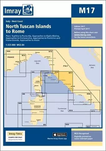
Chart scale 1:325 000 Plans included: Scarlino to Punta Ala (1:85 000) Approaches to Giglio Marina (1:10 000) Approaches to Civitavecchia (1:40 000) Approaches to Fiumicino and Fiuma Grande (1:50 000) Approaches to Anzio (1:50 000) On this 2017 the latest known depths have been applied. Harbour developments at Civitavecchia and Fiumicino are included as is the restricted area on the approach to Anzio. The Corsican Channel TSS is shown, as are the extents of Marine Protected Areas on this chart. The chart specification has been improved to show coloured light flashes. There has been general updating throughout.
ISBN: 9781846238765
Dimensions: unknown
Weight: 180g
2 pages
New edition